Just a trip to the grocery store or a wheel around the block for some air can be stressful and dangerous during this challenging time of physical distancing due to COVID-19. It doesn’t take long to realize that keeping the required two-metre distance from others is almost impossible in congested parts of the city. Pedestrians find themselves stepping onto the streets to stay apart and, as this is not an easy option when using a mobility device, many of us are left with the risk of not maintaining the required distance from others.
Looking for solutions, SCIO has proudly partnered with MapinHood, a personalized navigation app specifically designed to source accessible and safe routes in your Toronto-area neighbourhood. The company is looking for people from Toronto to pilot their new app.
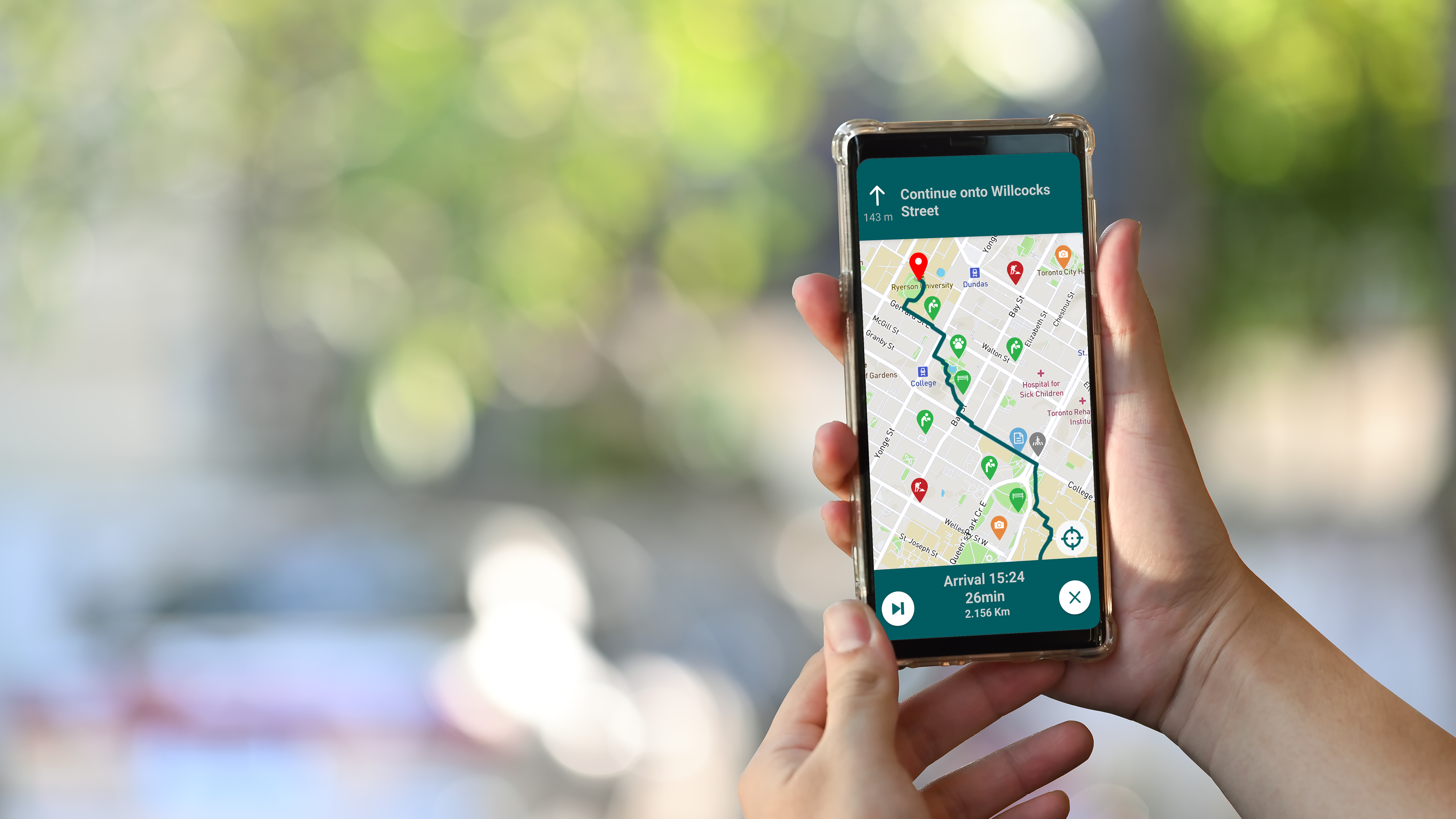
Distinguishing it from other accessible navigation apps, MapjnHood takes gradient data into account while generating routes, routing you away from steep slopes along the way. It also provides information on potential obstacles and closures in real time through crowdsourcing, as users have the ability to tag objects in order to help fellow users.
The app’s newly introduced Physical Distancing features include:
- ‘Avoid Crowds/Busy Streets’ setting into the routing engine enables users to reduce the risks of encountering others should they need to leave their homes for essential work, goods or supplies. (Based on historic pedestrian foot traffic and then eventually live pedestrian traffic data once there is enough user adoption in concentrated areas.) This feature is designed for users who rely on walking/wheeling to get to their essential service jobs as well as trips to the grocery store and other essential services.
- ‘Round Trip’ feature gives users the ability to set a timed route that starts and ends at their homes while avoiding all unnecessary risks while they are outside. The Road Trip feature is designed for people looking to get out for fresh air.
The MapinHood pilot with SCIO’s Toronto-based community is from May 22 until August 20, 2020, with quick feedback surveys provided to users on a monthly basis.
Give it a go! Here’s the registration and app download process:
https://mapinhood.com/pilotRegister
iOS: tiny.cc/23x0jz
Android: tiny.cc/e3x0jz
Use this special code when registering from May 22: SCIO2020
Thanks for participating. It’s free!
Why MapinHood?
- Physical Distancing: Users are routed away from crowded sidewalks to help them distance and minimize risk of exposure during COVID-19.
- Avoid Hazards: Users are notified of any hazards or sidewalk furniture along the way to their destination.
- Find What you Need: Users are able to search for amenities near them and can get routed directly to the amenity of choice.
- Gradient Data: The app account for slopes and inclines while routing users. Select the “Avoid Steep Slopes” option to avoid all steep slopes while being routes.
- Customize your Routing: You select what you want to avoid while being routed to your destination by choosing your routing preferences in settings. (Example: By selecting avoid Construction, you will be routed away from construction closures when being routed to your destination.)
- Customize your Map: You select what type of sidewalk objects you would like to be notified of while being routed. (Benches, Public Toilets, etc.)
- Crowdsourcing: Users have the option to add sidewalk objects to the map, for others to interact with. For example: If you come across a new construction at an intersection that is not on the map, you can place a construction tag. By doing so, you will be allowing other users to account for it while being routed.
- Multiple Routes: Based on your pre-selected routing preferences, the app will always give you the choice between the Fastest, Most Accessible and Safest route to your destination.
- Safety Feature: Our safety feature will route you though the sidewalks with the best lighting and most foot traffic at night, while notifying you (and routing you away) of recent crime and car accident locations along the way.